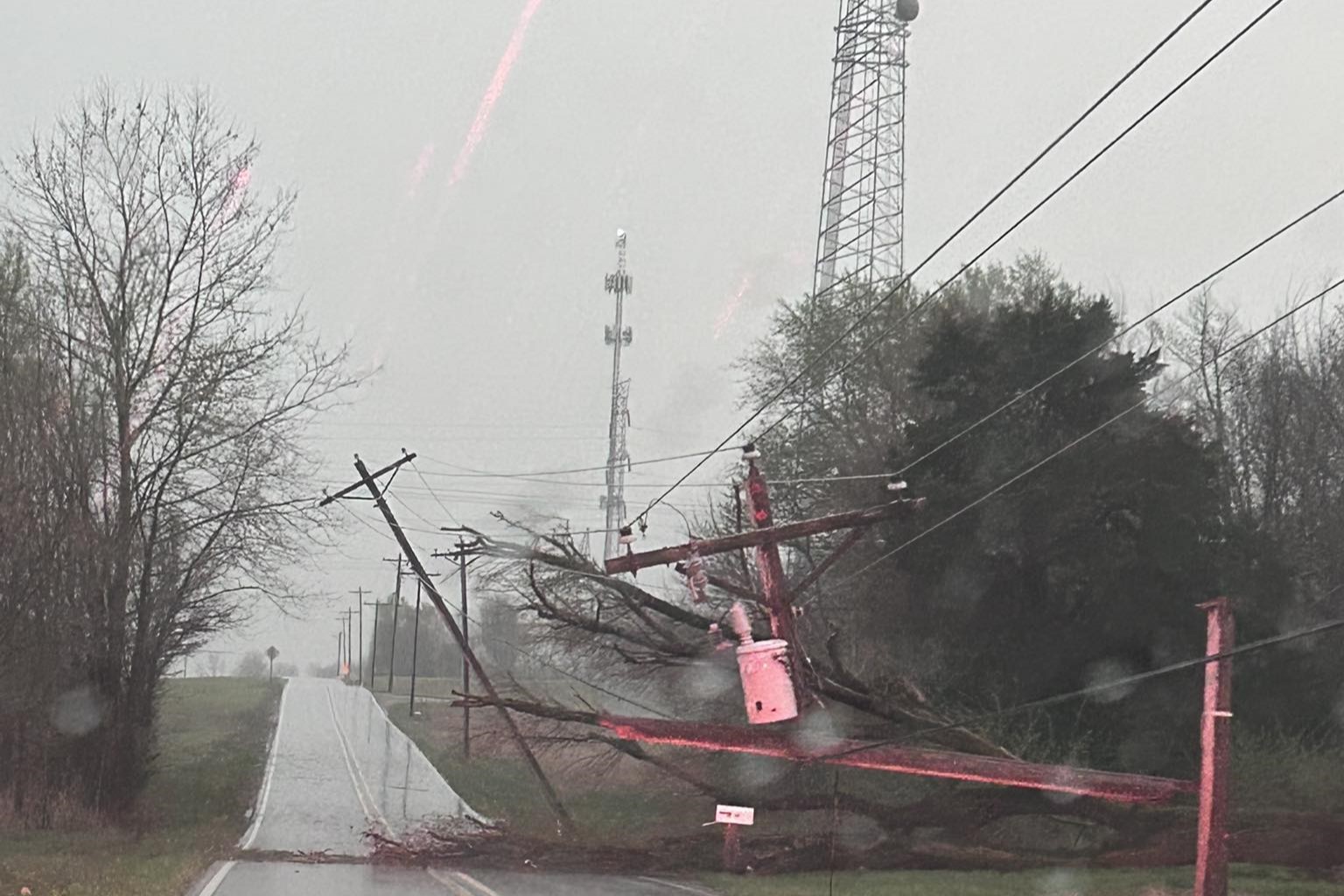
Preliminary reports from the National Weather Service determined that most of the March 30 storm damage in Monroe, Brown and Bartholomew counties was caused by straight-line winds between 65 and 85 miles per hour.
Mike Ryan of NWS spoke with WFIU/WTIU News on Monday when crews were assessing damages. He said that when winds intensify, people immediately think it’s a tornado.
“That's not always the case,” he said. “You know, sometimes it's more of what we call the straight-line feature or straight-line wind.”
NWS identified one weak tornado that travelled 30 yards on the ground.
Peak winds up to 80 miles per hour hit Monroe County’s Southside Christian Church. About a quarter of its roof was damaged from the tornado.
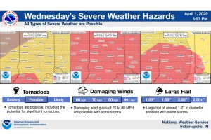
More severe weather is expected Wednesday night into Thursday morning. The Monroe County Community School Corporation said it's cancelling all after-school programs due to the weather forecast. You can track weather reports and closings on our website.
The church's playground structure was also blown down by a small EF-0 tornado Sunday, NWS said. (NWS Indianapolis)
11:30 a.m.
The Indianapolis division of the National Weather Service says it’s surveying storm areas in Monroe, Brown and Bartholomew County this morning to determine if there was tornado damage.
NWS Indianapolis issued a tornado warning around 7 p.m. Sunday for southeast Monroe County and southwest Brown County, as rotation was spotted in radar.
Meteorologist Mike Ryan says it’s not always clear in the moment if there was a tornado.
“Where it gets kind of tricky is like yesterday where you have these thunderstorms that have a lot of water with them, a lot of rain, and so these circulations can sometimes become kind of rain wrapped, so they're harder to spot with that,” he said.
Some roads in Bartholomew County were closed off Sunday evening from downed power lines.(Sheriff Chris Lane)
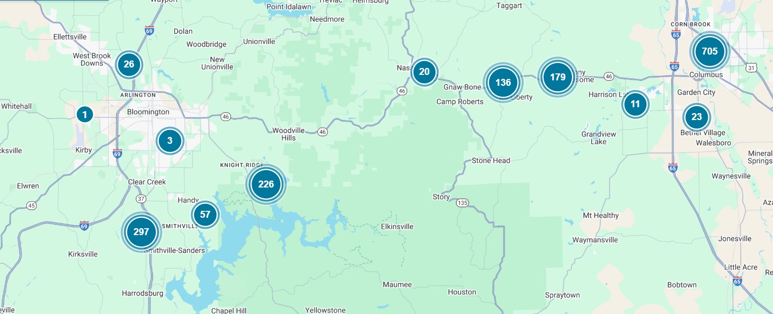
Duke Energy reported over 2,000 outages in Indiana this morning.
Duke Energy is reporting about 600 Monroe County customers without power at 9:30 a.m., the estimated time of restoration is 4 p.m.
Almost 800 are still without power Monday morning in Bartholomew County. Duke Energy said the estimated time of restoration is 6 p.m.
There are also major outages in Brown County (294 outages) and Tippecanoe County (110), and less than 100 reported outages in Fulton, Howard, Jackson and Ripley counties.
Some of the larger Duke Energy outage reports as of 9:30 a.m. Monday. (Duke Energy outage map)
South Central Indiana REMC reported 129 outages in Brown County as of 9:30 a.m. Monday.
Rain is expected through this week, with more severe weather in the forecast Wednesday.
Monroe County EMS is requesting anybody with property damage report to Indiana 211.
March 30
8:00 p.m. UPDATE:
Damage reports are coming in from severe thunderstorms that rolled through south central Indiana Sunday.
Numerous severe thunderstorm warnings and a few tornado warnings were issued for Monroe, Brown, Bartholomew, Shelby, and Decatur counties.
Tornado warnings were based on radar rotation from the National Weather Service along with reports of straight lined winds reaching 70 mph.
Local storm reports include one inch hail in Seymour, Columbus, Bedford, and Spencer; downed trees in Columbus and Brown County; downed power lines in Shoals, and 68 mph winds in Brown County.
Amateur radio reports tree tops taken out and trees toppled at the west gate of the Brown County state park.
Duke Energy is reporting more than 15,000 customers without power.
The tornado watch expired at 8 p.m., although a tornado watch continues for the far southern Indiana counties of Dubois, Orange, Scott, and Washington counties until 1 a.m.
The thunderstorm threat continues. Damaging wind gusts remain the main threat with a tornado risk for Bartholomew county over the next 30 minutes. These storms have a history of both large hail and damaging winds. #INwxpic.twitter.com/H0RHOlfEEM
Severe thunderstorms are rolling through south central Indiana bringing damaging wind gusts and large hail. National Weather Service officials said to expect storms to hit Bloomington and Martinsville around 7 p.m.
Severe Thunderstorm Warning including Bloomington IN, Bedford IN and Martinsville IN until 7:15 PM EDT pic.twitter.com/IeDkDgERGD
Local storm reports include 1 inch hail in Spencer, a power pole snapped in Kempton, trees down in Bicknell, and utility lines blown down in Perrysville.
4:00 p.m. UPDATE:
A tornado watch remains in effect for most of Indiana until 8 p.m. Threats include damaging winds, isolated tornadoes, and large hail.
National Weather Service reports indicate a line of storms continues to impact the northwestern portions of central Indiana with significant wind damage in Illinois. Additional developments are expected later this afternoon.
Severe thunderstorm warnings continue to be activated along with some tornado warnings as the system moves through.
We'll continue to update this story as new information comes in.