Give Now  »

Indiana Public Media | WFIU - NPR | WTIU - PBS

News Contact IPM News Indiana Public Media News

{ "banners": { "tv" : [ {"url" : "https://indianapublicmedia.secureallegiance.com/wtiu/WebModule/Donate.aspx?P=WTIUMCBNR&PAGETYPE=PLG&CHECK=2T6mTyo6yYuMn%2bAFYFwp%2bq1gzMC6uhq5nDjkJobrCdg%3d", "img" : "https://indianapublicmedia.org/images/banner-images/2-28-25-wtiu-bnr.jpg", "startingDate" : "1740718800000", "endingDate" : "1740891540000"} , {"url" : "https://indianapublicmedia.secureallegiance.com/wtiu/WebModule/Donate.aspx?P=WTIUMCBNR&PAGETYPE=PLG&CHECK=2T6mTyo6yYuMn%2bAFYFwp%2bq1gzMC6uhq5nDjkJobrCdg%3d", "img" : "https://indianapublicmedia.org/images/banner-images/3-2-25-wtiu-bnr.jpg", "startingDate" : "1740891600000", "endingDate" : "1741237140000"} , {"url" : "https://indianapublicmedia.secureallegiance.com/wtiu/WebModule/Donate.aspx?P=WTIUMCBNR&PAGETYPE=PLG&CHECK=2T6mTyo6yYuMn%2bAFYFwp%2bq1gzMC6uhq5nDjkJobrCdg%3d", "img" : "https://indianapublicmedia.org/images/banner-images/3-6-25-wtiu-bnr.jpg", "startingDate" : "1741237200000", "endingDate" : "1741409940000"} , {"url" : "https://indianapublicmedia.secureallegiance.com/wtiu/WebModule/Donate.aspx?P=WTIUMCBNR&PAGETYPE=PLG&CHECK=2T6mTyo6yYuMn%2bAFYFwp%2bq1gzMC6uhq5nDjkJobrCdg%3d", "img" : "https://indianapublicmedia.org/images/banner-images/3-8-25-wtiu-bnr.jpg", "startingDate" : "1741410000000", "endingDate" : "1741496340000"} , {"url" : "https://indianapublicmedia.secureallegiance.com/wtiu/WebModule/Donate.aspx?P=WTIUMCBNR&PAGETYPE=PLG&CHECK=2T6mTyo6yYuMn%2bAFYFwp%2bq1gzMC6uhq5nDjkJobrCdg%3d", "img" : "https://indianapublicmedia.org/images/banner-images/3-9-25-wtiu-bnr.jpg", "startingDate" : "1741496400000", "endingDate" : "1741751940000"} , {"url" : "https://indianapublicmedia.secureallegiance.com/wtiu/WebModule/Donate.aspx?P=WTIUMCBNR&PAGETYPE=PLG&CHECK=2T6mTyo6yYuMn%2bAFYFwp%2bq1gzMC6uhq5nDjkJobrCdg%3d", "img" : "https://indianapublicmedia.org/images/banner-images/3-15-25-wtiu-bnr.jpg", "startingDate" : "1741752000000", "endingDate" : "1742011140000"} , {"url" : "https://indianapublicmedia.secureallegiance.com/wtiu/WebModule/Donate.aspx?P=WTIUMCBNR&PAGETYPE=PLG&CHECK=2T6mTyo6yYuMn%2bAFYFwp%2bq1gzMC6uhq5nDjkJobrCdg%3d", "img" : "https://indianapublicmedia.org/images/banner-images/3-15-25-wtiu-bnr.jpg", "startingDate" : "1742011200000", "endingDate" : "1742097540000"} , {"url" : "https://indianapublicmedia.secureallegiance.com/wtiu/WebModule/Donate.aspx?P=WTIUMCBNR&PAGETYPE=PLG&CHECK=2T6mTyo6yYuMn%2bAFYFwp%2bq1gzMC6uhq5nDjkJobrCdg%3d", "img" : "https://indianapublicmedia.org/images/banner-images/3-16-25-wtiu-bnr.jpg", "startingDate" : "1742097600000", "endingDate" : "1742183940000"} ], "radio" : [ {"url" : "https://indianapublicmedia.secureallegiance.com/wtiu/WebModule/Donate.aspx?P=WFIUFDBNR&PAGETYPE=PLG&CHECK=tAXekcDG%2flgkr2wNtsqwhq1gzMC6uhq5nDjkJobrCdg%3d", "img" : "https://indianapublicmedia.org/images/banner-images/3-20-25-wfiu-bnr.jpg", "startingDate" : "1742443200000", "endingDate" : "1742875140000"} , {"url" : "https://indianapublicmedia.secureallegiance.com/wtiu/WebModule/Donate.aspx?P=WFIUFDBNR&PAGETYPE=PLG&CHECK=tAXekcDG%2flgkr2wNtsqwhq1gzMC6uhq5nDjkJobrCdg%3d", "img" : "https://indianapublicmedia.org/images/banner-images/3-25-25-wfiu-bnr.jpg", "startingDate" : "1742875200000", "endingDate" : "1742961540000"} , {"url" : "https://indianapublicmedia.secureallegiance.com/wtiu/WebModule/Donate.aspx?P=WFIUFDBNR&PAGETYPE=PLG&CHECK=tAXekcDG%2flgkr2wNtsqwhq1gzMC6uhq5nDjkJobrCdg%3d", "img" : "https://indianapublicmedia.org/images/banner-images/3-26-25-wfiu-bnr.jpg", "startingDate" : "1742961600000", "endingDate" : "1743047940000"} , {"url" : "https://indianapublicmedia.secureallegiance.com/wtiu/WebModule/Donate.aspx?P=WFIUFDBNR&PAGETYPE=PLG&CHECK=tAXekcDG%2flgkr2wNtsqwhq1gzMC6uhq5nDjkJobrCdg%3d", "img" : "https://indianapublicmedia.org/images/banner-images/3-27-25-wfiu-bnr.jpg", "startingDate" : "1743048000000", "endingDate" : "1743134340000"} , {"url" : "https://indianapublicmedia.secureallegiance.com/wtiu/WebModule/Donate.aspx?P=WFIUFDBNR&PAGETYPE=PLG&CHECK=tAXekcDG%2flgkr2wNtsqwhq1gzMC6uhq5nDjkJobrCdg%3d", "img" : "https://indianapublicmedia.org/images/banner-images/3-28-25-wfiu-bnr.jpg", "startingDate" : "1743134400000", "endingDate" : "1743220740000"} , {"url" : "https://indianapublicmedia.secureallegiance.com/wtiu/WebModule/Donate.aspx?P=WFIUFDBNR&PAGETYPE=PLG&CHECK=tAXekcDG%2flgkr2wNtsqwhq1gzMC6uhq5nDjkJobrCdg%3d", "img" : "https://indianapublicmedia.org/images/banner-images/3-29-25-wfiu-bnr.jpg", "startingDate" : "1743220800000", "endingDate" : "1743307140000"} , {"url" : "https://indianapublicmedia.secureallegiance.com/wtiu/WebModule/Donate.aspx?P=WFIUFDBNR&PAGETYPE=PLG&CHECK=tAXekcDG%2flgkr2wNtsqwhq1gzMC6uhq5nDjkJobrCdg%3d", "img" : "https://indianapublicmedia.org/images/banner-images/3-30-25-wfiu-bnr.jpg", "startingDate" : "1743307200000", "endingDate" : "1743393540000"} , {"url" : "https://indianapublicmedia.secureallegiance.com/wtiu/WebModule/Donate.aspx?P=WFIUFDBNR&PAGETYPE=PLG&CHECK=tAXekcDG%2flgkr2wNtsqwhq1gzMC6uhq5nDjkJobrCdg%3d", "img" : "https://indianapublicmedia.org/images/banner-images/3-31-25-wfiu-bnr.jpg", "startingDate" : "1743393600000", "endingDate" : "1743479940000"} , {"url" : "https://indianapublicmedia.secureallegiance.com/wtiu/WebModule/Donate.aspx?P=WFIUFDBNR&PAGETYPE=PLG&CHECK=tAXekcDG%2flgkr2wNtsqwhq1gzMC6uhq5nDjkJobrCdg%3d", "img" : "https://indianapublicmedia.org/images/banner-images/4-1-25-wfiu-bnr.jpg", "startingDate" : "1743480000000", "endingDate" : "1743566340000"} , {"url" : "https://indianapublicmedia.secureallegiance.com/wtiu/WebModule/Donate.aspx?P=WFIUFDBNR&PAGETYPE=PLG&CHECK=tAXekcDG%2flgkr2wNtsqwhq1gzMC6uhq5nDjkJobrCdg%3d", "img" : "https://indianapublicmedia.org/images/banner-images/4-2-25-wfiu-bnr.jpg", "startingDate" : "1743566400000", "endingDate" : "1743652740000"} ] }}
{ "lightboxes": { "tv" : [ {"url" : "https://indianapublicmedia.secureallegiance.com/wtiu/WebModule/Donate.aspx?P=WTIUMCLB&PAGETYPE=PLG&CHECK=2T6mTyo6yYtDgsQprWuZNm3L5BYddGq6PVAl6UEf65g%3d", "img" : "https://indianapublicmedia.org/images/banner-images/2-28-25-wtiu-lightbox.jpg", "startingDate" : "1740718800000", "endingDate" : "1740891540000"} , {"url" : "https://indianapublicmedia.secureallegiance.com/wtiu/WebModule/Donate.aspx?P=WTIUMCLB&PAGETYPE=PLG&CHECK=2T6mTyo6yYtDgsQprWuZNm3L5BYddGq6PVAl6UEf65g%3d", "img" : "https://indianapublicmedia.org/images/banner-images/3-2-25-wtiu-lightbox.jpg", "startingDate" : "1740891600000", "endingDate" : "1741237140000"} , {"url" : "https://indianapublicmedia.secureallegiance.com/wtiu/WebModule/Donate.aspx?P=WTIUMCLB&PAGETYPE=PLG&CHECK=2T6mTyo6yYtDgsQprWuZNm3L5BYddGq6PVAl6UEf65g%3d", "img" : "https://indianapublicmedia.org/images/banner-images/3-6-25-wtiu-lightbox.jpg", "startingDate" : "1741237200000", "endingDate" : "1741409940000"} , {"url" : "https://indianapublicmedia.secureallegiance.com/wtiu/WebModule/Donate.aspx?P=WTIUMCLB&PAGETYPE=PLG&CHECK=2T6mTyo6yYtDgsQprWuZNm3L5BYddGq6PVAl6UEf65g%3d", "img" : "https://indianapublicmedia.org/images/banner-images/3-8-25-wtiu-lightbox.jpg", "startingDate" : "1741410000000", "endingDate" : "1741496340000"} , {"url" : "https://indianapublicmedia.secureallegiance.com/wtiu/WebModule/Donate.aspx?P=WTIUMCLB&PAGETYPE=PLG&CHECK=2T6mTyo6yYtDgsQprWuZNm3L5BYddGq6PVAl6UEf65g%3d", "img" : "https://indianapublicmedia.org/images/banner-images/3-9-25-wtiu-lightbox.jpg", "startingDate" : "1741496400000", "endingDate" : "1741751940000"} , {"url" : "https://indianapublicmedia.secureallegiance.com/wtiu/WebModule/Donate.aspx?P=WTIUMCLB&PAGETYPE=PLG&CHECK=2T6mTyo6yYtDgsQprWuZNm3L5BYddGq6PVAl6UEf65g%3d", "img" : "https://indianapublicmedia.org/images/banner-images/3-12-25-wtiu-lightbox.jpg", "startingDate" : "1741752000000", "endingDate" : "1742011140000"} , {"url" : "https://indianapublicmedia.secureallegiance.com/wtiu/WebModule/Donate.aspx?P=WTIUMCLB&PAGETYPE=PLG&CHECK=2T6mTyo6yYtDgsQprWuZNm3L5BYddGq6PVAl6UEf65g%3d", "img" : "https://indianapublicmedia.org/images/banner-images/3-15-25-wtiu-lightbox.jpg", "startingDate" : "1742011200000", "endingDate" : "1742097540000"} , {"url" : "https://indianapublicmedia.secureallegiance.com/wtiu/WebModule/Donate.aspx?P=WTIUMCLB&PAGETYPE=PLG&CHECK=2T6mTyo6yYtDgsQprWuZNm3L5BYddGq6PVAl6UEf65g%3d", "img" : "https://indianapublicmedia.org/images/banner-images/3-16-25-wtiu-lightbox.jpg", "startingDate" : "1742097600000", "endingDate" : "1742183940000"} ], "radio" : [ {"url" : "https://indianapublicmedia.secureallegiance.com/wtiu/WebModule/Donate.aspx?P=WFIUFDLB&PAGETYPE=PLG&CHECK=tAXekcDG%2flizvLEFSbjC6m3L5BYddGq6PVAl6UEf65g%3d", "img" : "https://indianapublicmedia.org/images/banner-images/3-20-25-wfiu-lightbox.jpg", "startingDate" : "1742443200000", "endingDate" : "1742529540000"} , {"url" : "https://indianapublicmedia.secureallegiance.com/wtiu/WebModule/Donate.aspx?P=WFIUFDLB&PAGETYPE=PLG&CHECK=tAXekcDG%2flizvLEFSbjC6m3L5BYddGq6PVAl6UEf65g%3d", "img" : "https://indianapublicmedia.org/images/banner-images/3-25-25-wfiu-lightbox.jpg", "startingDate" : "1742875200000", "endingDate" : "1742961540000"} , {"url" : "https://indianapublicmedia.secureallegiance.com/wtiu/WebModule/Donate.aspx?P=WFIUFDLB&PAGETYPE=PLG&CHECK=tAXekcDG%2flizvLEFSbjC6m3L5BYddGq6PVAl6UEf65g%3d", "img" : "https://indianapublicmedia.org/images/banner-images/3-26-25-wfiu-lightbox.jpg", "startingDate" : "1742961600000", "endingDate" : "1743047940000"} , {"url" : "https://indianapublicmedia.secureallegiance.com/wtiu/WebModule/Donate.aspx?P=WFIUFDLB&PAGETYPE=PLG&CHECK=tAXekcDG%2flizvLEFSbjC6m3L5BYddGq6PVAl6UEf65g%3d", "img" : "https://indianapublicmedia.org/images/banner-images/3-27-25-wfiu-lightbox.jpg", "startingDate" : "1743048000000", "endingDate" : "1743134340000"} , {"url" : "https://indianapublicmedia.secureallegiance.com/wtiu/WebModule/Donate.aspx?P=WFIUFDLB&PAGETYPE=PLG&CHECK=tAXekcDG%2flizvLEFSbjC6m3L5BYddGq6PVAl6UEf65g%3d", "img" : "https://indianapublicmedia.org/images/banner-images/3-28-25-wfiu-lightbox.jpg", "startingDate" : "1743134400000", "endingDate" : "1743220740000"} , {"url" : "https://indianapublicmedia.secureallegiance.com/wtiu/WebModule/Donate.aspx?P=WFIUFDLB&PAGETYPE=PLG&CHECK=tAXekcDG%2flizvLEFSbjC6m3L5BYddGq6PVAl6UEf65g%3d", "img" : "https://indianapublicmedia.org/images/banner-images/3-29-25-wfiu-lightbox.jpg", "startingDate" : "1743220800000", "endingDate" : "1743307140000"} , {"url" : "https://indianapublicmedia.secureallegiance.com/wtiu/WebModule/Donate.aspx?P=WFIUFDLB&PAGETYPE=PLG&CHECK=tAXekcDG%2flizvLEFSbjC6m3L5BYddGq6PVAl6UEf65g%3d", "img" : "https://indianapublicmedia.org/images/banner-images/3-30-25-wfiu-lightbox.jpg", "startingDate" : "1743307200000", "endingDate" : "1743393540000"} , {"url" : "https://indianapublicmedia.secureallegiance.com/wtiu/WebModule/Donate.aspx?P=WFIUFDLB&PAGETYPE=PLG&CHECK=tAXekcDG%2flizvLEFSbjC6m3L5BYddGq6PVAl6UEf65g%3d", "img" : "https://indianapublicmedia.org/images/banner-images/3-31-25-wfiu-lightbox.jpg", "startingDate" : "1743393600000", "endingDate" : "1743479940000"} , {"url" : "https://indianapublicmedia.secureallegiance.com/wtiu/WebModule/Donate.aspx?P=WFIUFDLB&PAGETYPE=PLG&CHECK=tAXekcDG%2flizvLEFSbjC6m3L5BYddGq6PVAl6UEf65g%3d", "img" : "https://indianapublicmedia.org/images/banner-images/4-1-25-wfiu-lightbox.jpg", "startingDate" : "1743480000000", "endingDate" : "1743566340000"} , {"url" : "https://indianapublicmedia.secureallegiance.com/wtiu/WebModule/Donate.aspx?P=WFIUFDLB&PAGETYPE=PLG&CHECK=tAXekcDG%2flizvLEFSbjC6m3L5BYddGq6PVAl6UEf65g%3d", "img" : "https://indianapublicmedia.org/images/banner-images/4-2-25-wfiu-lightbox.jpg", "startingDate" : "1743566400000", "endingDate" : "1743652740000"} ] }}
true
true
true
true
true
true
true
true
true
true
true

Severe weather rolls through the state leaving 30,000 without power

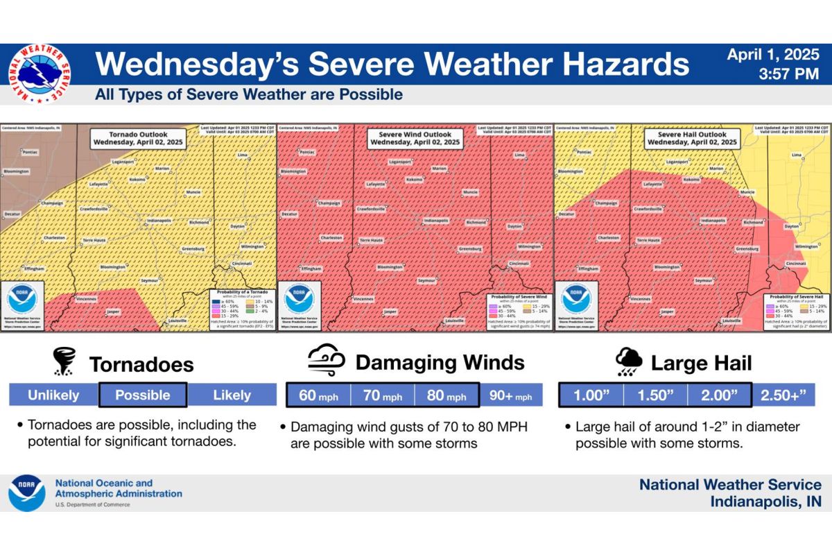
All severe weather hazards are possible Wednesday evening into Wednesday night.

All severe weather hazards are possible Wednesday evening into Wednesday night. (National Weather Service, Indianapolis)

Track delays, closings submitted to our newsroom and weather alerts here. 

Live television alerts | Live radio alerts

11:45 P.M. UPDATE:

Tornado watch for the western part of the state expired at 11. Thunderstorm warnings continue for Columbus, Seymour, and Greensburg areas.

Flash flooding warnings are in effect until 2 a.m. 

Damage reports are starting to come in. Most are from strong winds toppling power lines and trees. Duke Energy is reporting little more than 30,000 are without power.

A structure collapse is reported in Brownsburg with people unaccounted. Greencastle trained spotter reported 73 MPH winds.

Three semi-trucks are reported as overturned by winds in West Terre Haute near the state line. 

Tornado warnings earlier tonight from the national weather serivce included "tornado on ground" statements from Brownsburg to Carmel. 

More updates will come from the National Weather Service Thursday.

11:06 P.M. UPDATE:

There is a tornado warning for southeastern Monroe County, southeastern Brown County, southwestern Bartholomew County, northeastern Lawrence County and northwestern Jackson County until 11:30 p.m. 

A severe thunderstorm capable of producing a tornado was located 12 miles northeast of Bedford, moving northeast at 65 mph. Radar indicated rotation. Impacted locations include Spurgeons Corner, Waymansville, Elkinsville, Charles Deam Wilderness, Stone Head, Gnaw Bone, and Story.

10:57 P.M. UPDATE:

The National Weather Service in Indianapolis has issued a severe thunderstorm warning for southern Monroe County, southern Brown County, southwestern Bartholomew County, Lawrence County and Jackson County until 11:30 p.m. 

Severe thunderstorms were located along a line extending from near Bloomington to Bedford to 10 miles southeast of Shoals, moving northeast at 40 mph. Wind gusts up to 70 mph and penny size hail have been reported.

A tornado watch still remains in effect until 4 a.m. for central and south central Indiana.

There is also a flash flood warning for Johnson, Morgan, Shelby, Brown, Monroe, Greene, Owen and Putnam County until 2 a.m. Between 1 and 2 inches of rain have fallen. Additional rainfall amounts of 1 to 1.5 inches are
possible in the warned area. 

10:52 P.M. UPDATE: 

There is a tornado warning for south central Crawford County and southeastern Perry County until 11:30. A severe thunderstorm capable of producing a tornado was located 7 miles northeast of Whitesville, moving northeast at 60 mph. Radar indicated rotation.

10:49 P.M. UPDATE: 

There is a tornado warning for northeastern Lawrence County and northwestern Jackson County in south central Indiana until 11:15 p.m. A severe thunderstorm capable of producing a tornado was located near Bedford, moving northeast at 40 mph. Radar indicated rotation.

10:39 P.M. UPDATE:

The National Weather Service in Louisville has issued a tornado warning for Dubois, Crawford, Perry, and Orange County until 11:15 p.m. Severe thunderstorms capable of producing a tornado were located along a line extending from near Jasper to near Santa Claus, moving east at 50 mph. Radar indicated rotation.

10:31 P.M. UPDATE:

The National Weather Service in Indianapolis has issued a severe thunderstorm warning until 11 p.m for:

  • Southern Monroe County in south central Indiana
  • Southeastern Knox County in southwestern Indiana
  • Martin County in southwestern Indiana
  • Eastern Greene County in southwestern Indiana
  • Lawrence County in south central Indiana
  • West central Jackson County in south central Indiana
  • Daviess County in southwestern Indiana

Severe thunderstorms were located along a line extending from 9 miles north of Washington to 16 miles south of Bloomfield to Shoals, moving northeast at 70 mph. There are 60 mph wind gusts and penny size hail.

A tornado watch remains in effect until 11 p.m. for south central and southwestern Indiana. A tornado watch also remains in effect until 4 a.m for south central Indiana.

10:27 P.M. UPDATE: 

There is a tornado warning for Shelby, Hancock, Johnson and Marion County until 11 p.m.

A severe thunderstorm capable of producing a tornado was located over Greenwood moving northeast at 30 mph.

10:22 P.M. UPDATE:

The National Weather Service in Louisville has issued a tornado warning for Northern Orange County until 10:45 p.m. A severe thunderstorm capable of producing a tornado was located near Shoals, moving northeast at 50 mph.

This thunderstorm will remain over mainly rural areas of northern Orange County.

10:18 P.M. UPDATE:

NWS Louisville has also issued a tornado warning for Dubois County and Perry County until 10:45 p.m.

A severe thunderstorm capable of producing a tornado was located over Folsomville, moving northeast
at 65 mph. Radar indicated rotation. This storm will be near Jasper around 10:35 p.m.

10:01 P.M. UPDATE:

The National Weather Service in Indianapolis has issued a Tornado Warning for southern Martin County and southeastern Daviess County until 10:30 p.m.

A severe thunderstorm capable of producing a tornado was located near Jasper moving northeast at 60 mph. Locations impacted include Alfordsville, Shoals and Lacy.

9:56 P.M. UPDATE: 

A severe thunderstorm warning for Shelby, Monroe, Morgan, Brown, and Johnson County is in effect until 10:30 p.m. 

A severe thunderstorm was located near Martinsville, moving northeast at 60 mph. There is also penny-size hail.

9:55 P.M. UPDATE: 

A tornado warning for Dubois County is in effect until 10:30 p.m.

A severe thunderstorm capable of producing a tornado was located 7 miles southeast of Winslow, moving northeast at 45 mph. Rotation has been detected on radar. 

9:30 P.M. UPDATE: 

A severe thunderstorm warning remains in effect through 10 p.m. for Monroe, Morgan, Owen, Brown and Greene counties. 

A confirmed tordano was located over Carmel at 9:30 p.m. 

8:30 P.M. UPDATE:

Warnings are in effect as a line of severe storms race through south central Indiana. The storms are moving northeast at about 65 MPH. Radar is indicating rotation north of Terre Haute.

Thunderstorm warnings for Monroe County include threats of 70 MPH winds and quarter size hail.

4 P.M. UPDATE:

A tornado watch is in effect until 11 p.m.

Scattered storms are expected to begin followed by widespread storms this evening into the overnight hours. Forecasters at the National Weather Service said the best chance for severe weather will be from 5 p.m. until 1 a.m.

Damaging winds, tornadoes with large hail, and flash flooding are possible. Cancellations are being reported for evening activities.

Vigo County Commissioners announced a travel advisory until 5 p.m. Thursday due to the potential of flooding, downed power lines, and uprooted trees.

A flood watch is in effect from 8 tonight through Sunday morning. 

ORIGINAL STORY:

Another round of severe weather is possible Wednesday evening. Forecasters at the National Weather Service in Indianapolis indicate all hazards are possible including tornadoes, damaging winds of up to 80 mph, and hail two inches wide.

Heavy rainfall on saturated ground may also lead to flash flooding as more rain is expected through Saturday.

The active weather pattern pushes daytime highs back up to mid-70’s Wednesday before falling to the mid-60s Thursday.

A wind advisory takes effect for gusts up to 50 mph Wednesday morning until 1 a.m. Thursday.

Track delays, closings submitted to our newsroom and weather alerts here. 

Get Daily News Headlines, delivered free to your inbox every weekday

Want to contact your legislators about an issue that matters to you? Find out how to contact your senators and member of Congress here.

Support For Indiana Public Media Comes From

Recent Environment Stories