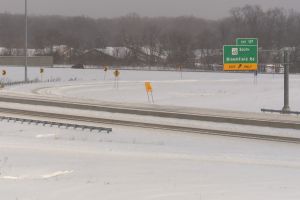


The travel warning is still in effect as crews continue to clear the roads. (Devan Ridgway/WTIU News)
Track delays, closings submitted to our newsroom and weather warnings here.
Updated snowfall amounts National Weather Service Jan. 5-6
JENNINGS North Vernon 13.0
DAVIESS Elnora 12.0
DECATUR Westport 12.0
MORGAN Martinsville 11.3
HENDRICKS Brownsburg 11.0
BARTHOLOMEW Columbus 10.8
JACKSON Seymour 10.5
MARION Eagle Creek Park 10.0
MORGAN Monrovia 10.0
KNOX Bicknell 9.8
LAWRENCE Avoca 9.8
SHELBY Shelbyville 9.8
MONROE Bloomington 9.5
OWEN Spencer 9.5
BROWN Stone Head 9.0
SULLIVAN Carlisle 8.0
VIGO Terre Haute 7.8
GREENE Bloomfield 7.3
PUTNAM Cloverdale 7.2
DAVIESS Washington 7.0
MARTIN Shoals 7.0
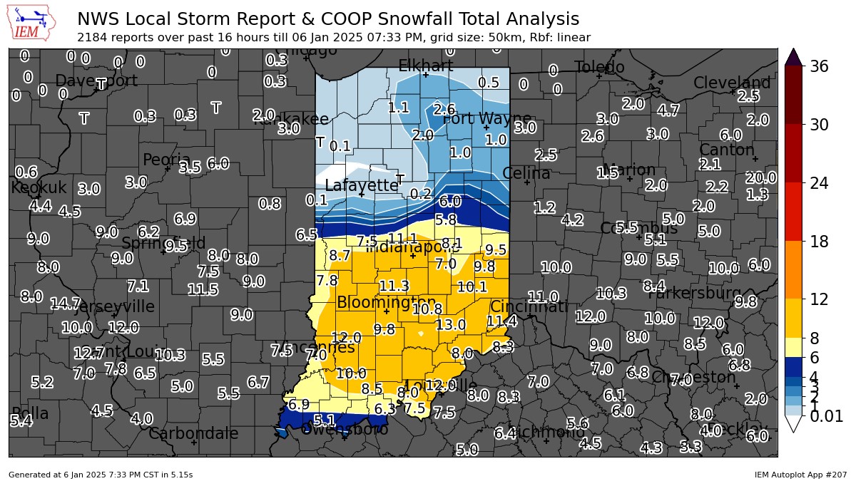
A map of snowfall reports received by NWS Indianapolis. (National Weather Service)
MONDAY EVENING UPDATE:
The National Weather Service's winter storm warning has lifted. The Department of Homeland Security's travel warning is still in place for parts of south-central Indiana. Monroe County has lifted to a travel watch.
Hazardous road conditions are reported from the accumulated snow and ice. The governor dispatched the National Guard to help local authorities with stranded vehicles carrying approximately 40 stranded motorists - getting them to safety or warm locations and helping change tires.
From midnight to 9 a.m. Monday, the Indiana State Police responded to:
- 228 slide offs
- 210 property damage crashes
- 34 personal injury crashes
Snowfall has largely ended. Matthew Eckhoff, a meteorologist with the National Weather Service, said Indiana will see scattered flurries tonight, but these are not expected to stick.
Below freezing temperatures are expected the rest of the week, according to Eckhoff. This means the snowfall will stick around all of this week and most of next.
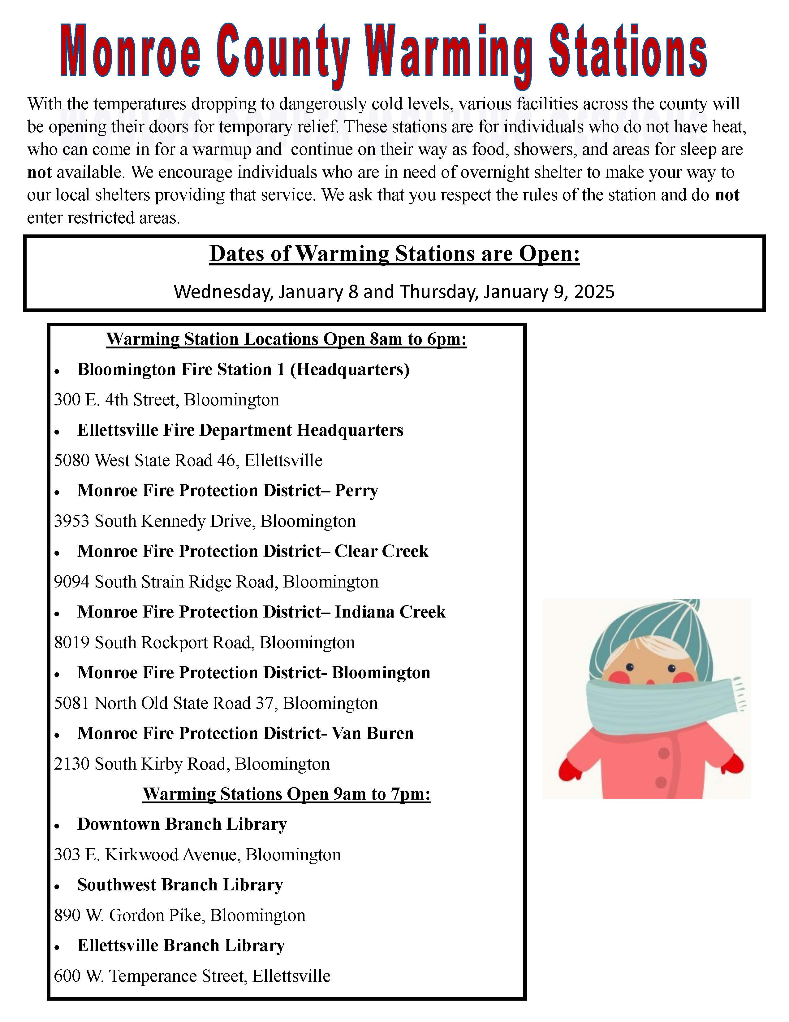
The Monroe County Emergency Management says warming centers will be open Wednesday and Thursday for the upcoming freeze.
MONDAY AFTERNOON UPDATE:
National Weather Service officials are slowly canceling the winter storm warning as snow tapers off over south central Indiana.
The warning remains in effect for a few counties including Monroe County until 7 p.m. for an additional inch of snow.
Travel warnings remain in effect for emergency travel only. State transportation officials in the southwest district said now that the storm has moved eastward, 150 plows are in full force clearing the roads.
Read more: Stay home, prepare for freezing temperatures, says Monroe County Emergency Management
Bloomington Mayor Kerry Thomson said snowplows have been out since yesterday morning and would continue to clear roads. But she said many plowed roads are still slick due to the low temperatures.
"We are encouraging those who can stay home to stay home," she said.
Snowfall amounts reported to the National Weather Service include:
7.8 - Indianapolis
8.0 - Greensburg
8.0 - Columbus
7.5 - Shoals
9.0 - Bloomington
All MCCSC schools Tuesday will move to independent, self-paced eLearning. There will be no live instruction - lesson information will be communicated via Canvas and ParentSquare by 10:00 a.m. Tuesday. All in person programs and after-school activities are canceled.
Food service pickup for families will be available at Templeton and Fairview Elementary from 12-1:30 p.m. Families should RSVP at the form here.
Track delays, closings submitted to our newsroom and weather warnings here.
MONDAY MORNING UPDATE:
The winter storm warning continues until 7 p.m. as an additional two inches of snowfall is expected today. Cold temperatures will remain all week with highs in the upper 20s today and Tuesday and colder on Wednesday.
Mayor Kerry Thomson said city officials are directing those in need of overnight shelter to services offered by the local faith community.
Thomson said the city is also operating warming stations, while shelters that were open before the storm continue to offer services despite the storm.
“You don't need to be associated with one of those faith communities to volunteer. And they are looking for more volunteers,” she said.
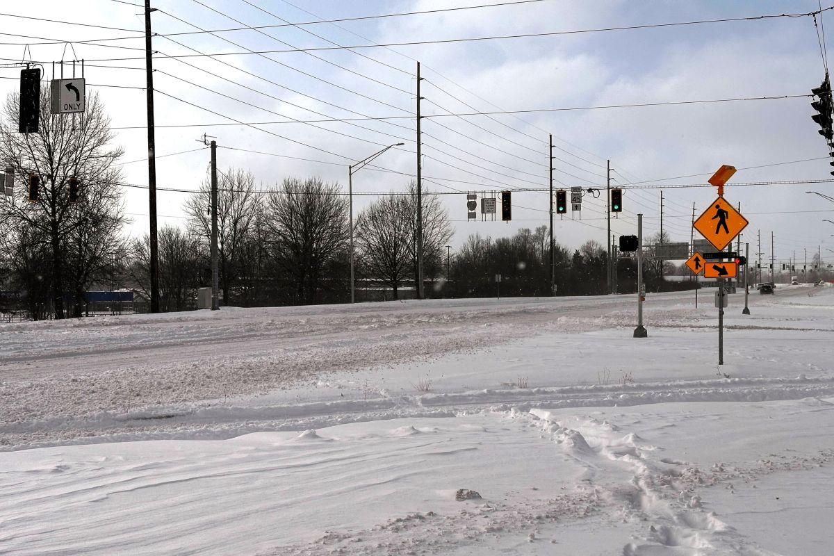
Roads are snow covered and drifting causing many counties to declare travel for emergency use only.
THREAD: These two pictures were taken from the far northern and far southern corners of our district, one-minute apart (Benton and Vigo Counties). 😯🥶
— INDOT West Central (@INDOT_WCentral) January 6, 2025
Right now, we are having some small challenges with blowing snow due to the high winds. 💨 pic.twitter.com/56XwL86lpm
Snowfall amounts reported to the National Weather Service include:
6.5 - Indianapolis
7.0 - Terre Haute
8.0 - Martinsville
9.0 - Bloomington
8.0 - Columbus
6.1 - Oolitic
7.0 - Brownstown
Forecasters at the National Weather Service in Indianapolis said snow has come to an end for the northwest part of the state and is pushing southeast. A heavier band of snow is setting up along the back end before ending this afternoon.
Track delays, closings submitted to our newsroom and weather warnings here.
SUNDAY NIGHT UPDATE:
The winter storm warning remains in effect until 7 p.m. Monday for additional snow and sleet accumulations between 1 and 3 inches. Ice and winds gusting to 40 MPH are creating treacherous travel conditions.
Monroe, Brown, Morgan, Bartholomew, Lawrence, Jackson, Orange, Washington counties and others are under travel warnings meaning roads should be used for emergencies only.
A number of closings have been submitted to our newsroom including a few schools, sanitation services, and more. Please check the status of your destination before traveling.
Snowfall amounts reported to the National Weather Service include:
4.5 - Indianapolis
3.5 - Terre Haute
4.5 - Bloomington
4.9 - Columbus
5.0 - Linton
5.0 - Bedford
SUNDAY UPDATE:
A winter storm warning is in effect for between 6 and 11 inches of heavy mixed precipitation. A tenth of an inch of ice and wind gusts up to 35 MPH are also predicted for most of the southern part of the state.
Travel 'watch' status advisories are in effect for Brown, Orange, and Washington counties in the broadcast area - meaning essential travel only. Most other counties are under a travel advisory.
Monroe County is under a travel advisory. Citizens should use caution and avoid snow-covered roads. Schools and businesses may begin to implement their emergency action plans. pic.twitter.com/HGJYXQo8pR
— WFIU/WTIU News (@WFIUWTIUNews) January 5, 2025
Reports range from snow covered roads and low visibility along and south of I-70 to little to no snow further north. Forecasters at the National Weather Service in Indianapolis measured 1.4 inches of snow in Indianapolis at 1 p.m.
Here's an updated snow accumulation projection map:
Noon Winter Storm Update
— NWS Indianapolis (@NWSIndianapolis) January 5, 2025
Actualización Mediodía de Tormenta Invernal
(English and Spanish graphics)
Updating snow accumulations for the I-70 corridor and points north as there will be a sharp snowfall gradient just north of the Indy Metro. #inwx pic.twitter.com/OYgkkQxaea
SATURDAY NIGHT UPDATE:
The winter storm warning takes effect Sunday morning at 7 a.m. until 7 p.m. Monday for south central Indiana including Bloomington, Seymour, Columbus, Bedford, and Nashville.
Heavy mixed precipitation is expected with total snow and sleet accumulations between 5 and 10 inches. Ice up to a tenth of an inch and 35 MPH wind gusts are expected to make travel conditions hazardous.
Here's the latest from the National Weather Service:
Here is all the latest information for the approaching #winter storm in one post. A Winter Storm Warning continues across much of central Indiana, with a Winter Weather Advisory far north/northwest. #INwx pic.twitter.com/vwMGyQ1biW
— NWS Indianapolis (@NWSIndianapolis) January 4, 2025
SATURDAY UPDATE:
A winter storm warning is now in effect from 7 a.m. Sunday to 1 p.m. Monday. National Weather Service officials are predicting heavy mixed precipitation with total snow and sleet accumulations to reach 5 to 8 inches.
Light ice accumulations are also anticipated along with winds of up to 35 MPH causing roads to become slick and hazardous. Tree limbs may down power lines. Hazardous conditions could impact the Monday morning commute.
Forecasters say while the exact details on timing are still uncertain, precipitation should start after 9 a.m. for south central Indiana and after Noon to the north.
Highest snow totals continue to look to be south of I-70 in the Bloomington to Columbus corridor.
Continue to monitor the forecasts as we update with more detailed thoughts going into tomorrow.
While the exact details on timing are still uncertain, confidence is increasing that outside of a period of freezing drizzle Sunday night, precipitation should remain all snow along and north of I-70 with a period of sleet to the south. Highest accumulations south of I-70. #INwx pic.twitter.com/K67ab0BTWB
— NWS Indianapolis (@NWSIndianapolis) January 4, 2025
ORIGINAL STORY, by Katy Szpak:
A winter storm headed toward the Ohio River Valley is expected to reach Bloomington Sunday.
The National Weather Service has issued a winter storm watch from Thursday afternoon through Monday evening for 28 counties, including Monroe county. There is a high probability of 6 inches or more of snow, with sleet and freezing rain from Sunday morning through Monday evening. Overnight wind gusts may reduce visibility and increase the chance for outages. Wind chill temperatures will likely reach below zero next week.
Aaron Updike, a meteorologist at the Indianapolis branch of the National Weather Service, said to “expect an impactful snow event."
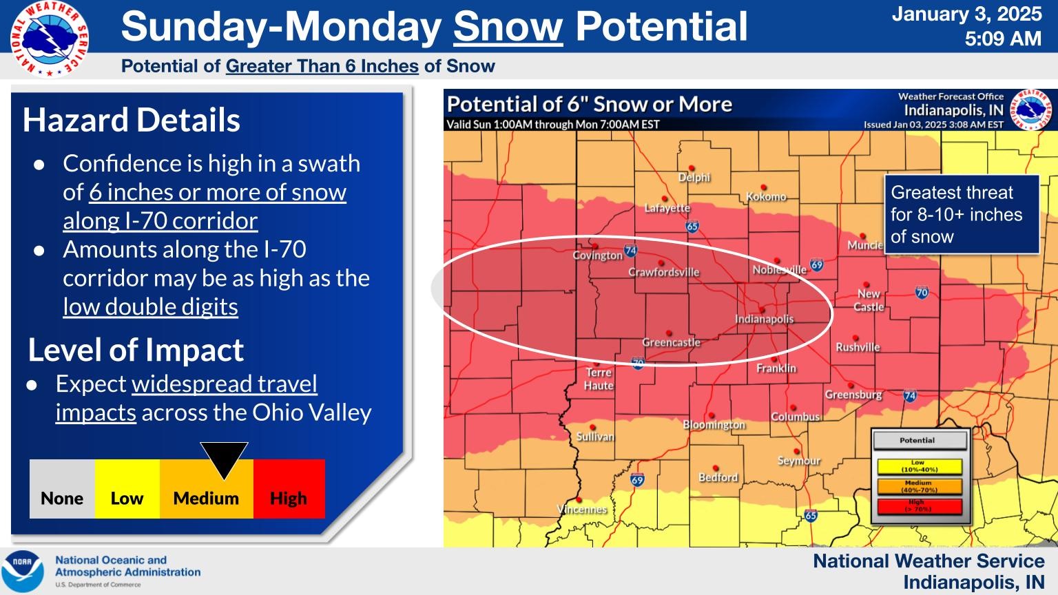
The Weather Channel is predicting 5 to 8 inches of snow Sunday, with potential for an additional inch of snow Monday.
Bloomington and 27 other counties are on a winter storm watch. A winter storm warning would most likely be issued on Friday or Saturday, Updike said.
"A watch just means that it's a little bit further out," he said. "We're preparing for the potential for a winter storm. When we issue a warning, that's when a winter storm is expected. So it's really just a timeline."
Updike said the last time the National Weather Service issued a winter storm warning for the Bloomington area was Feb. 2-4 2022, when there were reports of 6 inches of snow.
Sgt. Kevin Getz with the Indiana State Police said residents should gather emergency supplies and prepare for icy road conditions.
"If you don't have to be out there on the roads, don't. But we also understand those that work, if you have to get to your place of employment, give yourself plenty of time," he said.
Bloomington District troopers will patrol I-69 and major roadways on Sunday and Monday.
More than 500 Indiana Department of Transportation vehicles will be salting and plowing roads. This includes pretreating roads Saturday. INDOT said it takes two to three hours to complete a snow route. Drivers can check road conditions on INDOT’s social media and highway cameras at 511in.org, and advise drivers to slow down on the roads and give the snow plows room to work.
The First Christian Church on Kirkwood Avenue will be open for the next four days through the storm. Doors open at 8:30 p.m., and half of the 30 beds will be reserved for women until 9:30 p.m.
Bloomington Emergency Management is also looking to open warming centers at the fire stations next week.
You can find more winter storm information on the ready.gov website.