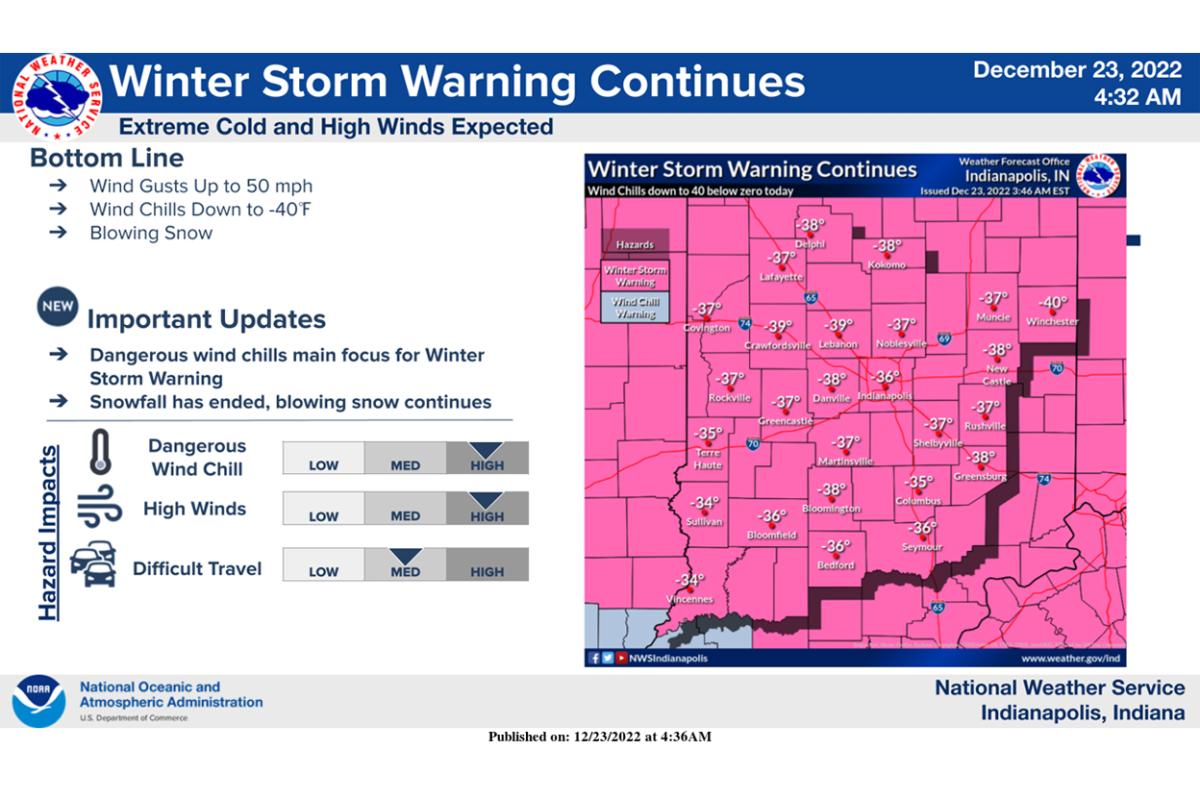
A Winter Storm Warning has been extended until 7 a.m. Saturday with the focus on the extremely cold wind chills and strong winds. Snow has come to an end, but blowing snow will remain a hazard.
Weather status by county in the WFIU/WTIU broadcast area as well as delays and closings reported to WFIU and WTIU News can be found here.
Crews are still out in full force across the district! 💪 We appreciate them for keeping us safe, especially during the holidays. They will be out maintaining roads as conditions dictate. CONT... pic.twitter.com/vgYmLmBP3C
A Winter Storm Warning will remain in place until 7 p.m. with the focus on the extremely cold wind chills and strong winds. Snow has come to an end, but blowing snow will remain a hazard.
With wind chills around -40 degrees, frostbite can occur in a matter of minutes.
National Weather Service forecasters report the last time Indianapolis failed to reach 0 degrees for a high temp was back on 1/18/1994 when the high was -4°F. To show how rare this is, since 1880, there have only been 16 days where the high did not reach 0 degrees.
Blowing and drifting snow, as well as bitter cold are still challenges for INDOT road crews. #YellowTrucks will continue clearing & treating state roads through at least the evening hours tonight.
Wind chills are now below -20° in areas. Forecasters say the snow has been lighter than anticipated in spots, with the heavier snows further east.
About 120 people are without power in downtown Bloomington just south of the former hospital site. About 50 are without power in the Ellettsville area. The Duke Energy website says power is expected to be restored around 3 a.m.
Jackson Co. is under a Travel Warning - which means travel is only allowed for emergency responders.
Travel still remains treacherous with blowing snow and reports of black ice as INDOT second shift crews begin at midnight.
A winter storm warning remains in effect for central Indiana from Terre Haute to Indianapolis until Friday at 7 p.m and for south central Indiana from Bloomington to Columbus to Washington until Friday at 1 p.m.
Weather status by county in the WFIU/WTIU broadcast area as well as delays and closings reported to WFIU and WTIU News can be found here.
If you look closely, you can see a few mini snownadoes on the road! ❄️🌪️ There are strong wind gusts happening across WC Indiana. 👀 Watch out for drifting snow.
National Weather Service forecasters say to expect temperatures to plummet into the evening following the cold frontal passage from west to east. Surfaces will quickly freeze as temperatures fall under 10 degrees by midnight. 3-5 inches of blowing snow this evening is still expected.
State police are asking the public not to call police or 911 for road updates, but to use online resources or call 1-800-261-7623.
Winter storm warning in effect for Terre Haute to Indianapolis until Friday at 7 p.m and for Bloomington to Columbus to Washington until Friday at 1 p.m.
Our first reports of snow coming in from Spencer. Snow will move east over the next few hours. ❄️
Winter Storm Warning will continue for most of Indiana. Flash freeze and rapidly deteriorating road conditions is expected around and during the evening commute. Weather officials say the best practice is to stay home.
Bottom Line: up to 55 mph wind gusts, wind chills to -30 degrees, flash freeze of wet roads, 2-5 inches of blowing snow.
Winter storm warning in effect for Terre Haute to Indianapolis 3 p.m. until Friday at 7 p.m.
Winter storm warning in effect for Bloomington to Columbus to Washington 4 p.m. until Friday at 1 p.m.
❄️❄️ Winter weather is inbound and our crews are hitting the road. Before you hit the road be sure to check out our TrafficWise app. It's the best way to find out road conditions across the state. TrafficWise is also available at https://t.co/95pDeLDdn9. ❄️❄️ pic.twitter.com/qLzAADf5tp